
The freedom, positivity, and bravery promoted by road trips encourage people to move forward. Driving through hundreds or even thousands of miles of scenery. When you want to leave your tired life behind for a while and take a breather, a car can take you on a scenic drive.
And among the many landscapes in the country, California tops the list. That's why we've compiled a list of the top 10 scenic drives in California. Let's take a romantic escape through California scenic drives!
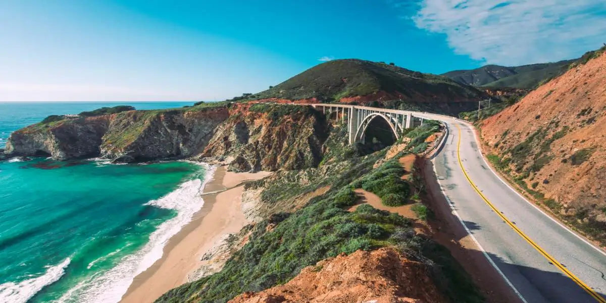
Pacific Coast Highway
The Pacific Coast Highway is one of the world's most beautiful coastal highways and is generally traveled from San Francisco to Los Angeles. But it extends a long way to the north and south.
It runs from Laguna Beach in Orange County in the south to Mendocino County at the southern end of Mangrove National Park in the north. There are 655 miles in length, with parking strips and observation decks along the way for photo ops.
It hugs the Pacific Ocean coastline, takes in the mountain scenery, and passes through state parks and specialty towns, making it perfect for excursions along the way. The entire route offers fantastic views of the coastline, reefs, and cliffs, among many other things.

(Pacific Coast Highway)
Death Valley Scenic Byway
Spectacular canyon views can be enjoyed in Death Valley. Of course, this road is not suitable for the summer months, but spring and fall are the best times to explore the area.
The road through Death Valley National Park winds through craggy mountains and dunes, and Zabriskie Point is the most famous viewpoint where you can watch the sunrise or sunset. Remember to bring plenty of water to keep you hydrated before heading to Death Valley.

(Death Valley Scenic Byway)
Highway 395
It's a north-south highway. This scenic drive stretches along the eastern side of the Sierra Nevada Mountains to Reno. The scenery on this highway is varied and perfect for a fall visit, being able to enjoy the yellow and orange maple leaf road and various lakes along the way.
From South Lake Tahoe near the beautiful Emerald Bay State Park, head south to Mono Lake Tufa State Natural Reserve. Finish the day with a trip to Mono Lake for sunset viewing.

(Highway 395)
Route 66
Route 66 originates in Lake Michigan, starting in Chicago, traveling through Illinois, Missouri, Kansas, Oklahoma, Texas, New Mexico, and Arizona, and ending in California. Spanning eight states, three time zones, and a total length of 2,423 miles. 66 ends at the Santa Monica Pier, where there is a sign for photos.
You can find many vintage signs, old-fashioned hotels, and ghost towns along this section of the route. Perfect for vintage lovers to visit.
Starting from the direction of Needles, make your way towards the coast. You will travel through the desert up to the oasis and is a very historical journey.

(Route 66)
Palms to Pines Scenic Byway
The journey is 56 miles in total. Traveling through the stunning Sonora Desert to the San Bernardino National Forest, you'll see snow-covered mountaintops, and the diverse flora, fauna, and native landscapes of the entire trip are a visual treat.
From forests and reservoirs to arid cactus-covered areas, deserts, rocky outcrops, and a vast expanse of blue sky with no end in sight. On this tour, you can also visit Joshua Tree National Park, an hour away, for unique boulder and desert scenery.

(Palms to Pines Scenic Byway)
Rim of the World Scenic Byway
This 110-mile journey takes you on Scenic Highway 18 between Lake Arrowhead and Big Bear Lake. It passes through the San Bernardino National Forest, and because of its elevated terrain, the view is elevated with panoramic views of the mountains.
The best time to visit this scenic highway is from May through October when the weather is sunny and the temperatures are favorable. In winter, the road may be closed due to snow. If you want to stay longer, head to Big Bear Lake, where you can take part in a variety of outdoor activities.

(Rim of the World Scenic Byway)
Tioga Road
This is a highway that offers beautiful views of the National Park. It is 39 miles long and travels through forests, lakes, and granite landscapes along the way. During this stretch, you can visit Olmsted Point, which is the most famous viewpoint in the area.
You can see the Yosemite valley and its famous granite landscape. If you want to stay longer, there are also camping spots available in the national park to see more of the scenery. But, this stretch of highway is only open from June to November due to winter snow. So pay attention to the season before you go there.

(Tioga Road)
Kings Canyon Scenic Byway
Kings Canyon Scenic Byway, also known as Highway 180, is located in central California. This scenic drive is 50 miles in length, but there are plenty of stops along the way, including different waterfalls, trails, canyon views, and more. For a clearer view of the valley, head to the Junction View lookout point, which also gives you a view of the stacked mountains of Kings Valley.
Of course, you can also visit the most famous Big Stump, which was originally the largest tree in the area, but unfortunately, only the roots remain. By the way, there are signs all over the national park to beware of bears, reminding you that all food and drink should not be left in the car.

(Kings Canyon Scenic Byway)
Angeles Crest Highway
This scenic drive crosses Angeles National Forest and San Gabriel Mountains National Monument, and is the highest elevation highway in Southern California, with many nearby attractions besides to national parks. For example, the Los Angeles Botanical Garden and Universal Studios.
This is one of the most exciting scenic roads in California with countless curves that you need to be aware of while driving. By the time you reach the end of the road, there's an observatory with views of the city of Los Angeles.

(Angeles Crest Highway)
Avenue of the Giants
It's a 52-mile-long scenic drive with towering redwood trees on both sides. The most famous attraction is Humboldt Redwoods State Park, and the most famous trail on this road is the Big Tree Trail, where the trees grow so tall they can make you feel peaceful and calm.
Throughout the park, there are many trails, viewpoints, and campgrounds to visit and choose from. There are also many exhibits to see, including the visitor center.

(Avenue of the Giants)
Final thoughts
California's scenic drives have always been one of the travelers' favorites. We've listed just 10 of these scenic drives. And there are so many more stunningly scenic routes for you to explore as you head to California for an epic road trip and a dazzling driving experience.
So buckle up, roll down the windows, and experience California's natural wonders on the wide-open scenic drive!